The Huron Creek watershed is an approximate 3.4 square mile watershed located in north central Houghton County in the Upper Peninsula of Michigan. Municipalities located within this watershed include the City of Houghton, Portage Township, and the villages of Dodgeville and Hurontown. |
| LOCATION |
|---|
The watershed empties into Portage Lake, which is connected to Lake Superior by a canal to the north and by a dredged channel in Portage Lake to the south. Portage Lake and the associated canal cuts the Keweenaw Peninsula, which extents out into Lake Superior from the Upper Peninsula of Michigan, into two. |
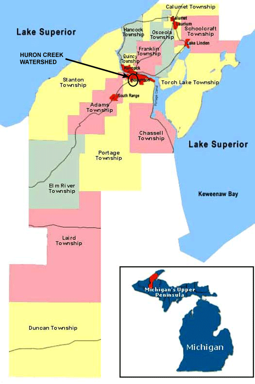 |
The map to the left locates the watershed within Houghton County.
www.coppercountry.com/ HoughtonCounty.php |
| WATERSHED BOUNDARIES |
|---|
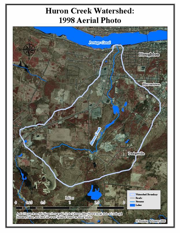
The watershed is located in an area of concentrated urban development. Huron Creek, the main waterway in the watershed, is routed through multiple culverts. It is approximately 3.3 miles in length.
|
The creek’s source is in an area of wetlands located in the southwest corner of the watershed. The creek then flows to the east and north, and empties into the Portage Canal at the watershed’s northern “tip.” Huron Creek flows through areas of generally level to slightly sloping surface topography in the south and central portions of the watershed. Ground surface topography becomes sloping to steep in the north central part of the watershed near Sharon Avenue. Downstream from this area, Huron Creek passes through a narrow wooded corridor and underneath Michigan highway M-26. Lastly, before emptying into the Portage Canal, the creek passes through a popular waterfront park and recreation area. |
|
| CLIMATE |
|---|
Indicative to the north central part of United States, the region’s continental climate is defined by westerly winds that dictate the weather patterns and by winters with prolong periods of snow cover. Lake Superior affects the climate of the Keweenaw Peninsula immensely. The lake dampens the temperature variation in comparison to much of central US. Average summer temperatures (°F) range from highs in the mid 70’s to lows in the mid-55’s. Average winter temperatures range from the mid-20’s to single digits. The lake also causes significant amounts of lake effect snow to fall on the region. On average 215.6 inches of snow falls on the peninsula each year. In Houghton County, the total average yearly precipitation is estimated at 207.8 inches.
Microclimate affecting the watershed can be generated from the general north-south downward slope into the canal. This orientation is such that the watersehd receives more sun in the summer months.
The following report contains graphs of (i) Average Snow Fall by Month; (ii) Average High and Low Temperature by Month; and (iii) Average Snowfall by Month: Average Precipitation and Temperature.
The following report contains graphs of (i) Record Snow Fall by Month; (ii) Record Temperature by Month; (iii) Record Daily Precipitaton by Month; and (iv) Average Solar Radiation by Month: Record Precipitation and Temperature.
| TOPOGRAPHY |
|---|
Contours showing the watershed's topography are included in the following aerial photograph.
Aerial Photo of Huron Creek Watershed (1998)