There
have been two dumps located on the Huron Creek Watershed, the first landfill
operated for about fifteen years in the 1950’s closing in the early 1970’s.
It was used as a burning dump, where everything that would be burned was
burned. This was located north of Sharon Ave.
The next dump was located where what is now Pizza Hut and was only in
operation for a couple of years. Around 2000, an orange and yellow discharge
was observed leaking from the former landfill into the creek. The DEQ
wrote a letter to the City of Houghton explaining that something needed
to be done to prevent contamination of the creek in the fall of 2005.
The City of Houghton then contracted out the construction of a leachate
collection.
The system that was designed consists of a trench on the west side of
the creek extending from the culvert under Sharon Ave to roughly Miner’s
State Bank. The bottom of the trench is set at the level of the creek
bottom, the trench is lined with an impermeable liner and a perforated
pipe is placed in the bottom of the trench. The trench is then backfilled
with pea stone to create a porous collection area. The liner is then wrapped
up over the backfill and upslope to prevent seeps from escaping through
the hillside above the trench. The City of Houghton installed the system
in the fall of 2006 and it began operation in December. The perforated
pipes empty to a sump where the leachate is collected and pumped into
the sanitary sewer. A significant flow has been observed entering the
collection system.
The leachate being collected contains high concentrations of iron and
ammonia along with traces of other metals. It is assumed that annual clean
out of the pipes for iron bacteria and other clogging material will be
necessary. The total cost of the system was about $100,000 and has an
expected lifespan of about 30 years.
Other issues from this landfill include discharge of methane gas, which
is being collected by a soil vapor extraction system and treated using
activated carbon.
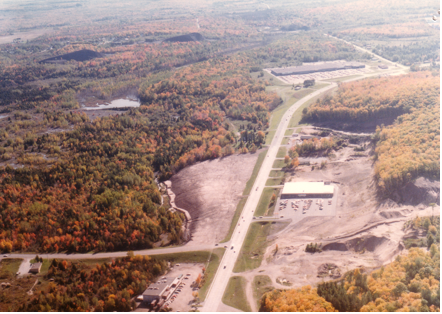
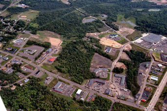
| In this view from the mid-1980s, the covered landfill can be seen just to the left (east) of M-26 and just above (south) of Sharon Avenue. The recently constructed leachate collection system is located in the streambed to the left (east) of the landfill. | In this recent photograph of the watershed, the intersection of Sharon Avenue and M-26 is seen in the bottom left. The red structure (Pizza Hut) sits above the former landfill. The old burning dump was located below (north) of Sharon, which is roughly in middle of the lower quarter of the photo. |
 |
 |