Sandstone Trip Details
 

Keweenaw Geoheritage Field/Boat Trips--

July 21-31, 2014


July 25-26 Jacobsville Sandstone   
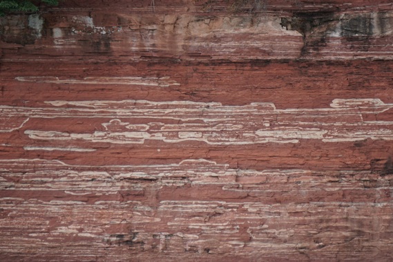
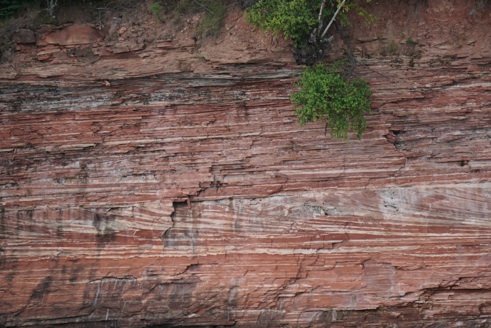
This trip is to see and understand the red rocks that were carried by rivers from the Huron Mountains (which were huge then) into the great valley of the Keweenaw rift. The best way is via the lake, where we will visit Pt Isabelle, Point Louis, Rabbit Island, Traverse Bays, Rabbit Bay and Jacobsville/Lower Entry. We will see the important fossils of the redbeds at Horseshoe Harbor and the Nonesuch Shale at the Gratiot River Mouth. Click on Green words below for more content.

What’s included:  Van and Boat transport and lunch. No overnight costs covered. Vans may be joined in Houghton one hour before the meeting time and transport back to Houghton from the end point each day is availble to those who want/need it.


Day 1 (July 25):  Visiting Expert: Dr John Gierke
8:30 am: meet at Burnette Park on the Gay-Lac la Belle road, 9:00 am: Point Isabelle visit Jacobsville outcrop.
10:00 am~3:30 pm: Board Agassiz at Grand Traverse, visit 
Point Louis, Grand and Little Traverse Bays.  Lunch anchored off Rabbit Island--possible trip to Point Abbaye (If time and conditions allow). Rabbit Bay and Jacobsville cliffs to Lower entry cliffs. Dock at Jacobsville.
3:30 pm: Jacobsville Discussion with long time residents at the Community Building.
5:00 pm: Back to Houghton from Jacobsville by van.


Day 2 (July 26) Visiting Expert: Dr Alex Guth:
8:30 am:  meet at Visitor Center, Copper Harbor. 
9:30 am: Horseshoe Harbor.  Copper Harbor Conglomerate and Stromatolites.  Gentle walk of ~0.3 mi, 0.6 RT. 
12:00 pm:  Lunch at Copper Harbor Visitor’s Center.
1: 15 pm: Eagle River Bridge, Eagle River.
2:15 pm: To Gratiot River mouth by van, walk shoreline to see Nonesuch Shale.  Flat walk of ~0.4 miles RT.
3:30 pm: Lily Pond Boat Launch, meet Agassiz for boat trip to Freda, to observe Freda Sandstone cliffs from boat. Back to Lily Pond. 5:30 pm: Van to KBC, Houghton.http://www.geo.mtu.edu/~raman/SilverI/Sandstonehttp://www.mtu.edu/geo/department/faculty/gierke/http://www.michiganwatertrails.org/location.asp?ait=av&aid=292http://www.geo.mtu.edu/~raman/SilverI/Sandstone/Pt_Isabelle.htmlhttp://www.geo.mtu.edu/%7Eraman/SilverI/Lake/Traverse.htmlhttp://www.geo.mtu.edu/~raman/SilverI/Sandstone/Pt_Louis.htmlhttp://www.geo.mtu.edu/%7Eraman/SilverI/Lake/Traverse.htmlhttp://www.geo.mtu.edu/~raman/SilverI/Sandstone/Rabbit_Island.htmlhttp://www.geo.mtu.edu/~raman/SilverI/Sandstone/Rabbit_Bay.htmlhttp://www.geo.mtu.edu/~raman/SilverI/Sandstone/JVille_Quarries.htmlhttp://www.geo.mtu.edu/~alguth/index/Welcome.htmlhttp://www.geo.mtu.edu/~raman/SilverI/BlackLavas/Horseshoe.htmlhttp://www.geo.mtu.edu/~raman/SilverI/BlackLavas/Eagle_River.htmlhttp://www.geo.mtu.edu/%7Eraman/SilverI/Lake/Gratiot_River_Mouth.htmlhttp://outdoormichigan.org/feature/12162http://www.geo.mtu.edu/~raman/SilverI/Lake/Freda.htmlhttp://www.keweenawbrewing.comshapeimage_3_link_0shapeimage_3_link_1shapeimage_3_link_2shapeimage_3_link_3shapeimage_3_link_4shapeimage_3_link_5shapeimage_3_link_6shapeimage_3_link_7shapeimage_3_link_8shapeimage_3_link_9shapeimage_3_link_10shapeimage_3_link_11shapeimage_3_link_12shapeimage_3_link_13shapeimage_3_link_14shapeimage_3_link_15shapeimage_3_link_16

What to bring:  Several layers for wind and cold conditions, possible rain? But it could be warm also! Strong sneakers or light hikers for shoes. Camera! Good spirits. Questions.


Brockway Mountain


Hunter's Point


Cobble Beach


Stromatolites


Alluvial Fanglomerates


Sandstones


Cobble Beach

 
Oliver Bay
Pt Isabelle Shore
Bete Gris Beach


Park Here
Pt Isabelle Shore
Rabbit I Spit
Rabbit Art Community
Craig Quarry
Wolf & Jacobs Quarry
Stone Quarry Lake
Dock
Point Louis
Pt Isabelle
Brunette Pk
Tobacco R
Grand TraverseCruise
Tentative AbbayeCruise
Lower Entry
Freda Trip

Lily Pond 
North Entry
Freda Sands at Houghton Breakers
Mill

Redridge Sands
Cliffs
Freda Cliffs
Freda Mill
Freda Sands


Steve Trynoski

Steve Trynoski

Steve Trynoski