Floods can happen almost anywhere. Rivers are the main agent, so big river systems draining large drainage basins are most hazardous. The key concept at rivers which is helpful to understand flooding is the floodplain.


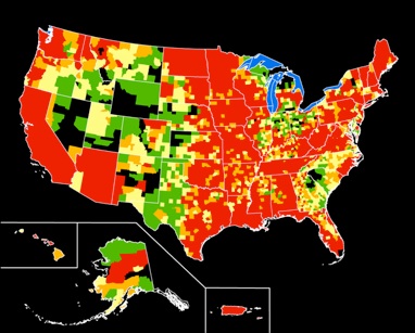
Presidential disaster declarations related to flooding in the United States, shown by county: Green areas represent one declaration; yellow areas represent two declarations; orange areas represent three declarations; red areas represent four or more declarations between June 1, 1965, and June 1, 2003. Map not to scale. Sources: FEMA, Michael Baker Jr., Inc., the National Atlas, and the USGS
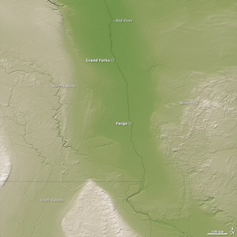
The repetition of flooding in the Red River basin is mostly due to its topographic setting (wide floodplain) and geologic history, as illustrated in this image. Made with data from the Shuttle Radar Topography Mission (SRTM), the image shows ground elevation in shades of green, tan, and white. Low-elevation areas are green, while higher elevation regions are tan and white.
NASA image created by Jesse Allen, using SRTM data provided courtesy of the University of Maryland’s Global Land Cover Facility. Caption courtesy NASA Jet Propulsion Laboratory, edited by Holli Riebeek. The full caption is available on the JPL Photojournal page.