Finding the Fault
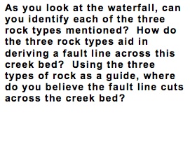
Keweenaw Fault
Waterfalls all over the world are appreciated for their uniqueness and beauty. Geologically speaking, waterfalls are significant because they have an interesting past. That is certainly the case for waterfalls all along the Keweenaw Peninsula. Here you see the highest of three falls found along the Hungarian Falls Trail. The three different rock types identified in this location present clues to understanding geological history of the Keweenaw.
Approximately 1.1 billion years ago, the Keweenaw was a place of active lava flows. These lava flows were created by a stage of rifting. The enormous weight of repeated lava flows and rifting caused the rock bed to sink, or sag. As the surrounding rock eroded away, it began to fill in where the sagging occurred. The older, igneous rock (basalt) was buried by younger sedimentary rock (conglomerate).
Then, approximately 1.04-1.08 billion years ago, the landscape changed dramatically due to a plate collision along the Grenville tectonic zone. Because of the enormous compressional pressure created along the Keweenaw Peninsula, the rock bed was forced upward in a thrust fault. The force from the compressional action tilted the igneous rock bed, and offset the rock layers by as much as 3-5 kilometers. When this happened, the older layers of basalt were uplifted high above the surrounding sedimentary layers and left dipping toward the northwest.
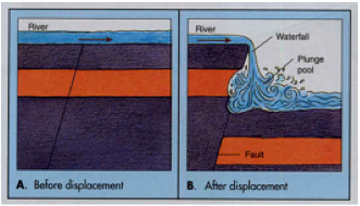
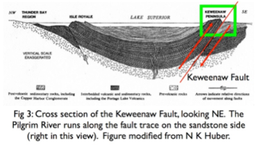
Tectonic activity in the area soon quieted. This meant that the rock was left alone to weather and erode, and the fault was buried under sedimentary rock. More recently, within the last 2 million years, a period of glacial activity has exposed the fault again by carving away the softer sedimentary rock (sandstone) under which it was buried. As the glaciers retreated, glacial runoff carved out the landscape, and created the incredible waterfall you see at this site today.
Geoscience Big Idea #4 Big Ideas
Earth is continuously changing. Many of the geologic features on Earth occur near plate boundaries and the resulting landscape is an interaction between rock that is uplifted and rock that is destroyed.
Stats
name Keweenaw Fault, Hungarian Falls
location Hubbell, Michigan
KMZ download HungFallsGTour.kmz
subjects Faults
Author Angela L. Ernstes
Strategic Math
Linden Grove Middle School
This work was supported by National Science Foundation award #0831948.
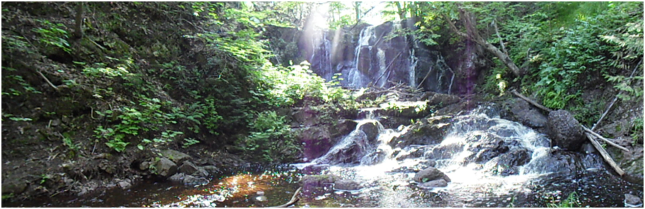


As you observe the rocks both upstream and downstream, you may notice they don’t exactly look the same. They differ in color and makeup, and they differ in they way they are layered. Looking downstream first, you’ll notice the rocks are reddish and are relatively flat-lying. These reddish rocks are Jacobsville Sandstone (1). They can be found in many places to the south of the Keweenaw Fault. Looking upstream, there are two types of rock present. You can see both basalt (also called diabase) and conglomerate. Basalt (2) is a dark rock, originating from lava flow, and is very hard. Conglomerate (3) is a sedimentary rock that contains many smaller cobbles within the larger boulder. The most interesting thing about the upstream rocks is how they have been tilted and lifted above the sandstone.
When you see different rock types, as you do here, with different layering patterns, it often indicates a point of geologic contact called a fault. At Hungarian Falls, the point of contact lies just below the ledges of the waterfall.
1. The Fault 2. Dam 3. Crossbedding 4. Potholes 5. Plunge Pool 6. Bigger River? History