
Eggers A A, 1971. The geology and petrology of the Amatitlán quadrangle, Guatemala. Unpublished PhD thesis, Dartmouth College, Hanover, New Hampshire, 221 p
Eggers A A, 1975, Geological Map of the Amatitlán 1:50,000 Quadrangle, Guatemala. Hoja 2059 II-G Instituto Geográfico Nacional, Guatemala
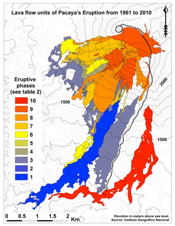
Matías Gomez, Ruben Otoniel. 2009, Volcanological map of the 1961-2009 eruption of Volcan de Pacaya, Guatemala (MS thesis) Michigan Technological University, Houghton, MI, United States (USA).
Matías Gomez. RO, WI Rose, JL Palma and RP Escobar-Wolf, 2012, Map of the 1961-2010 eruption of Pacaya Volcano, Guatemala, GSA Digital Map and Chart Series 10, 10 pp. doi:10.1130/2012.DMCH010