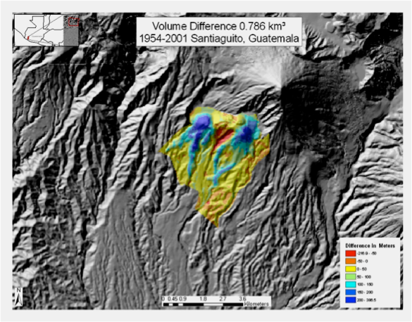
Geologic/Volcanologic Maps
 

Topographic changes

Durst, Kelly S. Erupted magma volume estimates at Santiaguito and Pacaya Volcanoes, Guatemala using digital data models MS thesis Michigan Technological University, Houghton, MI, United States (USA), 2008.


Ebmeier SK J Biggs, TA Mather, JR Elliott, G Wadge, F Amelung, 2012 A method for measuring large topographic change with INSAR: lava thicknesses, extrusion rate and subsidence rate at Santiaguito Volcano, Guatemala, Earth Planet Sci Lett 335-336: 216-225.


Mapping demonstrates that Santa Maria’s volume is subequal to Santiaguito’s, if we count the 1902 eruption as part of Santiaguito. It also shows that Santiaguito has become increasingly dominated by exogenous lava flows, and has shifted its extrusion from the El Brujo vent back to Caliente since 1975.

Geologic/Volcanologic Maps


Escobar Wolf, R, RO Matias Gomez and WI Rose 2010 Geologic Map of Santiaguito Volcano, Guatemala, Geol Soc Amer Digital Map and Chart Series, 8, DOI 10.1130/2010.DMCH008.


Rose, W. I., Santiaguito Volcanic Dome, Guatemala, Geol. Soc. Amer. Bull., 83, 1413, 1972b.