

Integrated ocean observation systems (IOOS) have received extensive public and government attention, with an aim at predicting the response of coastal ecosystems to global climate change; improving the safety and efficiency of maritime operations; mitigating the damages from natural and environmental hazards; and maintaining ocean and coastal resources [GOOS Report No. 125]. By efficiently linking between monitoring network, modeling and management, an IOOS can form an "end-to-end" system with forecast capability. Building and maintaining an observational network, however, is extremely costly, so that an optimal design of this system is a key issue that directly affects whether or not an IOOS will succeed. Observing System Simulation Experiments (OSSEs), which were used by Charney et al. [1969] for the Global Atmospheric Research Program (GARP), have been adopted for the design of an observing system aimed to improve ocean prediction through the use of data assimilation [Hackert et al., 1998; Raicich and Rampazzo 2003; Ballabrera-Poy et al. 2007].
The objectives of this research is to use OSSEs to help design an optimal sampling strategies in Massachusetts coastal waters in terms of assisting forecasting system in this region. OSSEs in this research was conducted through twin experiment, which consists of three major components. The framework is presented below:
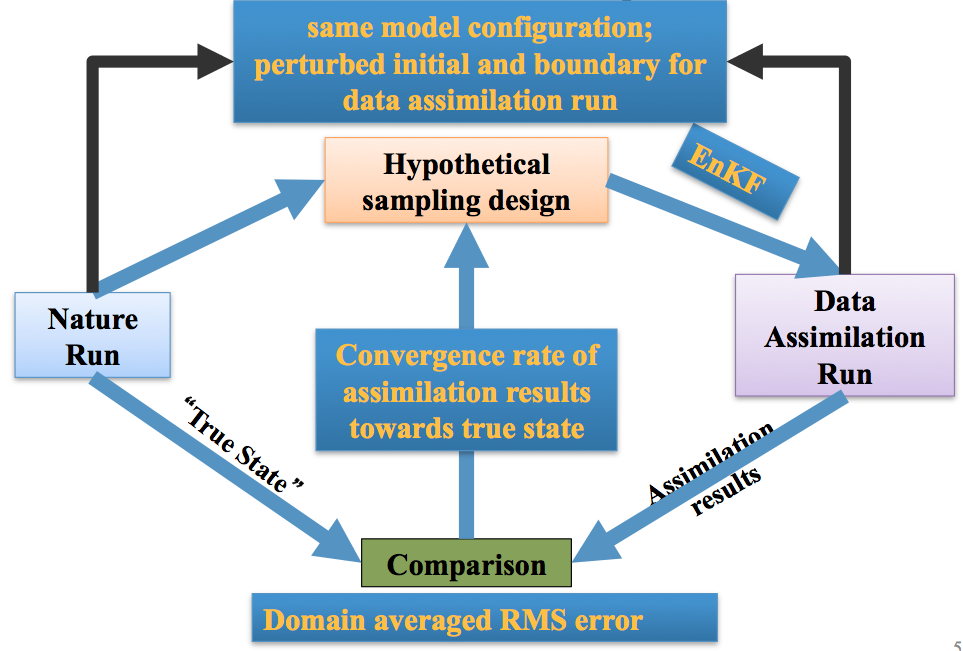
1) “Nature Run”. This is provided by a hindcast model run incorporating the best available knowledge on physics and biology and serves as a proxy for Real Nature. The model outputs of “Nature Run” are treated as “true state” to represent realistic phenomenology and variability of the system state. 2) Hypothetical observing network. Hypothetical sampling designs are simulated by extracting the synthetic observational data at hypothetical monitoring sites from the “true state” from “Nature Run” and adding random noise to represent observational errors. 3) Data assimilation runs. Experiments are performed by initializing the model with a perturbed (wrong) initial conditions and assimilating observational data from different hypothetical observing networks, respectively. By comparing results from assimilation runs based on different hypothetical monitoring plans, the sensitivity of the model convergence rate towards the “true state” to the design of the observing network (i.e. sampling variables, sampling locations and sampling frequencies) can be quantified. Consequently, an optimal observing system design will be derived from these hypothetical monitoring plans to meet the requirement for the short- and long-term forecast capability of model system. In this study, Ensemble Kalman Filter (EnKF) will be adopted as the data assimilation method for the OSSEs.
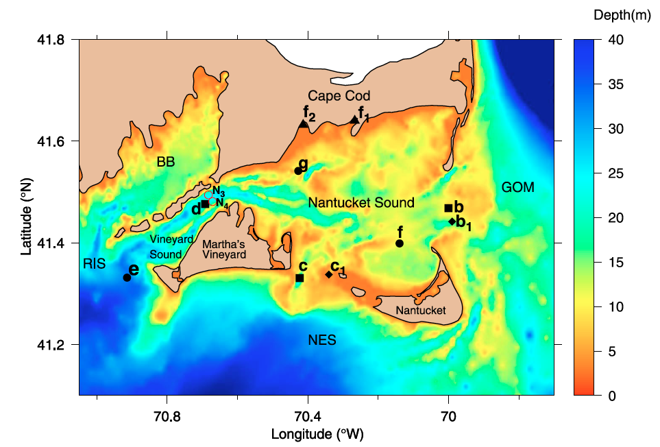
Nantucket Sound (NS) was selected as a pilot OSSE site for the design of an optimal monitoring network in Massachusetts (Fig. above, test sampling sites are shown too). Bounded by Cape Cod on the north, Nantucket Island and Martha’s Vineyard Island (MVI) on the south, NS is a tidally-dominated, “flow-through” system that connects Cape Cod inlets, bays, and estuaries to adjoining “upstream” waters (the Gulf of Maine to the east and the New England shelf to the south) and “downstream” waters (Vineyard Sound (VS) and Buzzards Bay (BB)). Due to strong tidal flushing around islands and significant temporal variation in wind forcing, currents in NS are characterized by complex geometrically controlled multi-scale variability.
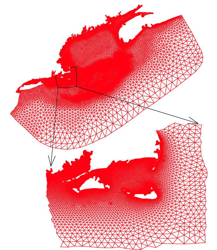
The twin data assimilation experiments in NS were conducted in the subdomain area of NS shown in Fig. above. This subdomain is linked to GOM-FVCOM through a one-way nesting approach, with the horizontal resolution varying from 0.3-0.5 km inside NS to 9 km off the coast to the open boundary and the vertical resolution of ~0.3 m or less inside NS (the total number of vertical layers was 30). The model was driven by tidal forcing, surface wind stress and atmospheric pressure, surface heat flux, net precipitation minus evaporation, plus freshwater discharge from the coastal rivers. FVCOM-GOM2 was solved using the mode-split time integration approach, with time steps of 4.0 sec for the external mode and 40 sec for the internal mode.
Model validation: As we generate "true state" from the model, i.e. the "Nature Run", which implicitly assumed that our simulation model has resolved realistic dynamics, which would not be 100% true. (Indeed, it woudn't be true for any models). Therefore, a good model-data comparison is the prerequisite for a meaningful OSSE analysis. With resolution of the complex coastal geometry, the model captures both spatial and temporal variability of currents and stratification in NS (Fig. below). The accuracy of the model simulations provides a foundation to be used for OSSEs.
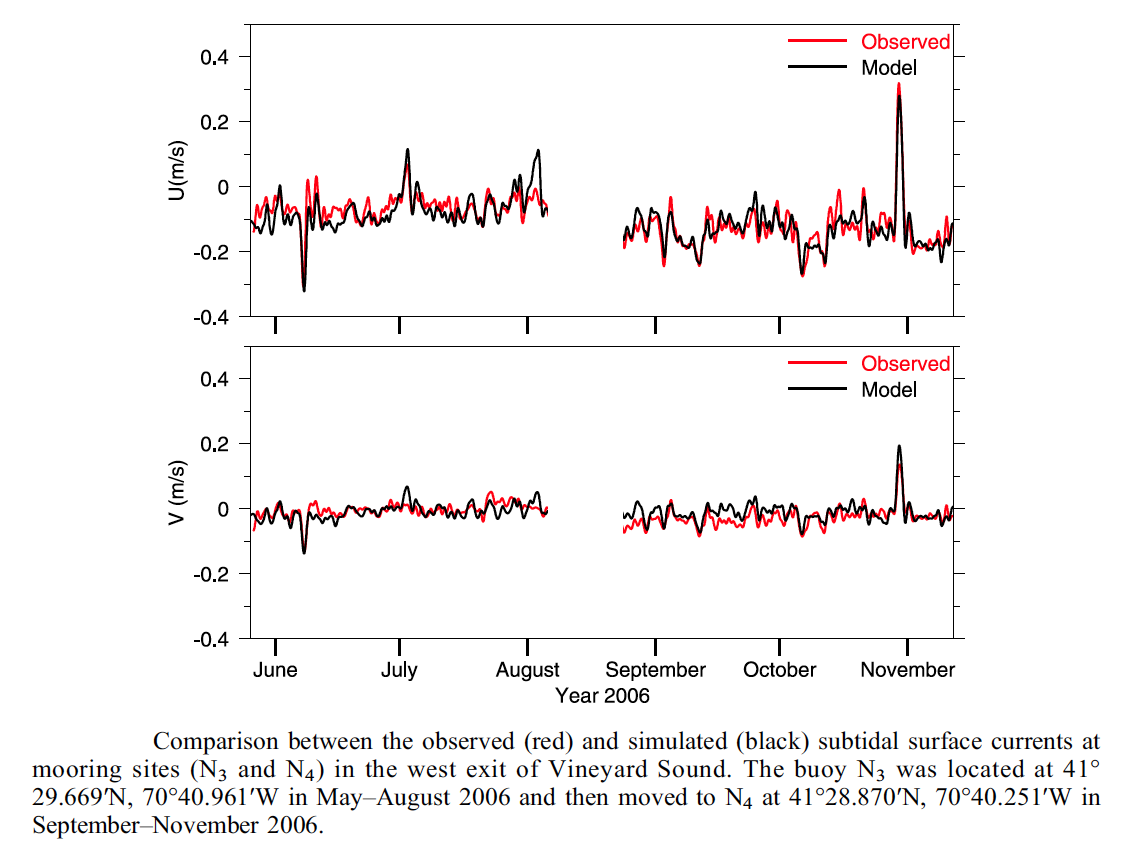
Model validation: