Scroll Down
Recent News
-

Award
Date: May 24, 2024
Lab member Stelle Barone was awarded King-Chávez-Parks (KCP) Initiative's Future Faculty Fellowship, receiving $35000 to support his PhD study. KCP provides State of Michigan funding to Michigan's 15 public universities to increase the pool of academically- or economically-disadvantaged candidates pursuing faculty teaching careers in postsecondary education.
-
Award
Date: Apirl 22, 2024
Lab member Ashish was awarded IMAGIN Scholarship and received $500. IMAGIN is a professional development organization committed to providing opportunities for its members to network with professionals who are using, creating, or maintaining spatial resources within Michigan.
-
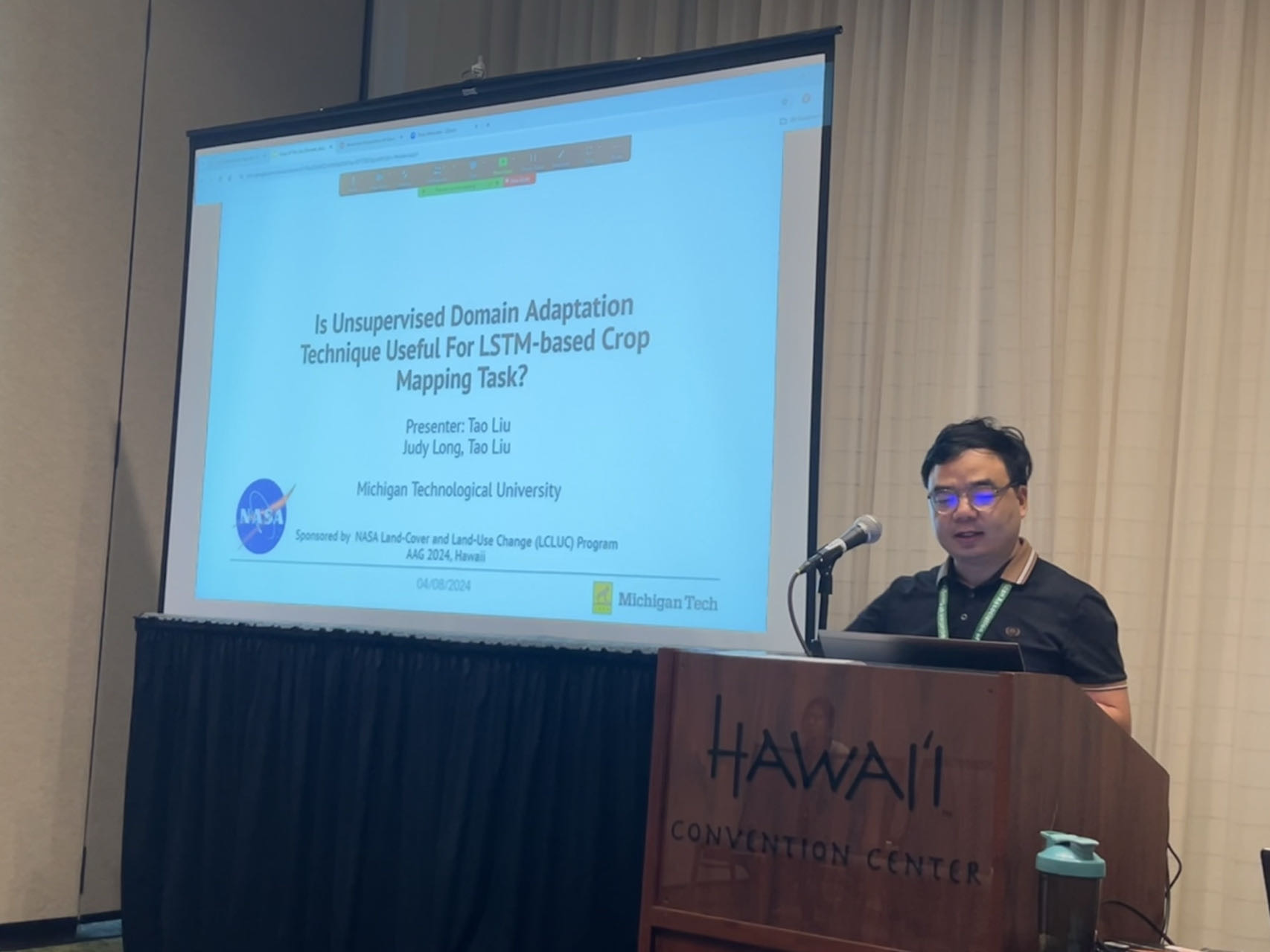
Conference presentation
Date: April 16, 2024
PI Tao Liu travelled to Hawaii to attend the AAG Annual Meeting and gave a presentation that discusses "Unsupervised domain adaption for large-scale crop mapping"
-
Welcome new lab member!
Date: May 15, 2024
Stelle Barone accepted the PhD position offered by Tao's Lab and he will start the PhD journey in 2024 Fall. Right now, he is working with Tao as research assistant.
Research
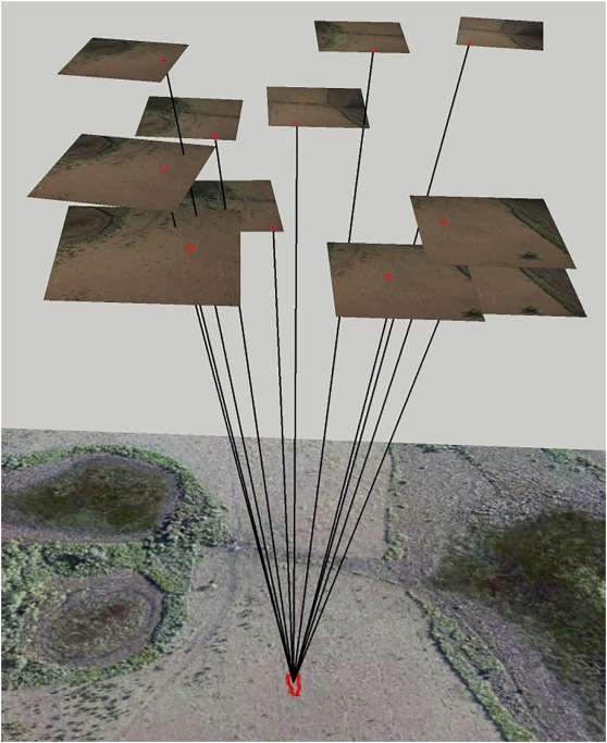
Landcover mapping using drone
The methods used to analyze sUAS images have not been significantly changed to accommodate the wide adoption of these images in the natural resource management field.Currently, traditional pixel-based and object-based image classification of an orthoimage produced through photogrammetric processing of hundreds or thousands of sUAS images is still the most common way for sUAS image classification. Images captured by sUAS differ from those captured by other remote sensing platforms since they tend to have smaller extent, higher spatial resolution, and large image-to-image overlap with varying objectsenor geometry compared to satellite or piloted aircraft images. We aim to develop new UAV image analysis approaches using AI and photogrammetric theories to fully exploit the UAV platform to better map landcover types and detect objects.
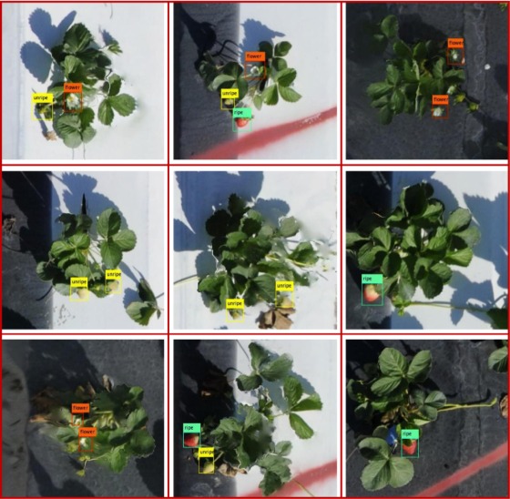
Object detection from remote sensing image
Object detection in remote sensing images is one of the most critical computer vision tasks for various earth observation applications. Previous studies applied object detection models to orthomosaic images generated from the SfM (Structure-from-Motion) analysis to perform object detection and counting. However, some small objects that are occluded from the vertical view but observable in raw images from the oblique views cannot be detected in the orthomosaic image, leading to an occlusion issue that cannot be resolved with the traditional orthophoto-based approach.We aim to fully detect and count the objects from all the angles from remote sensing platform.
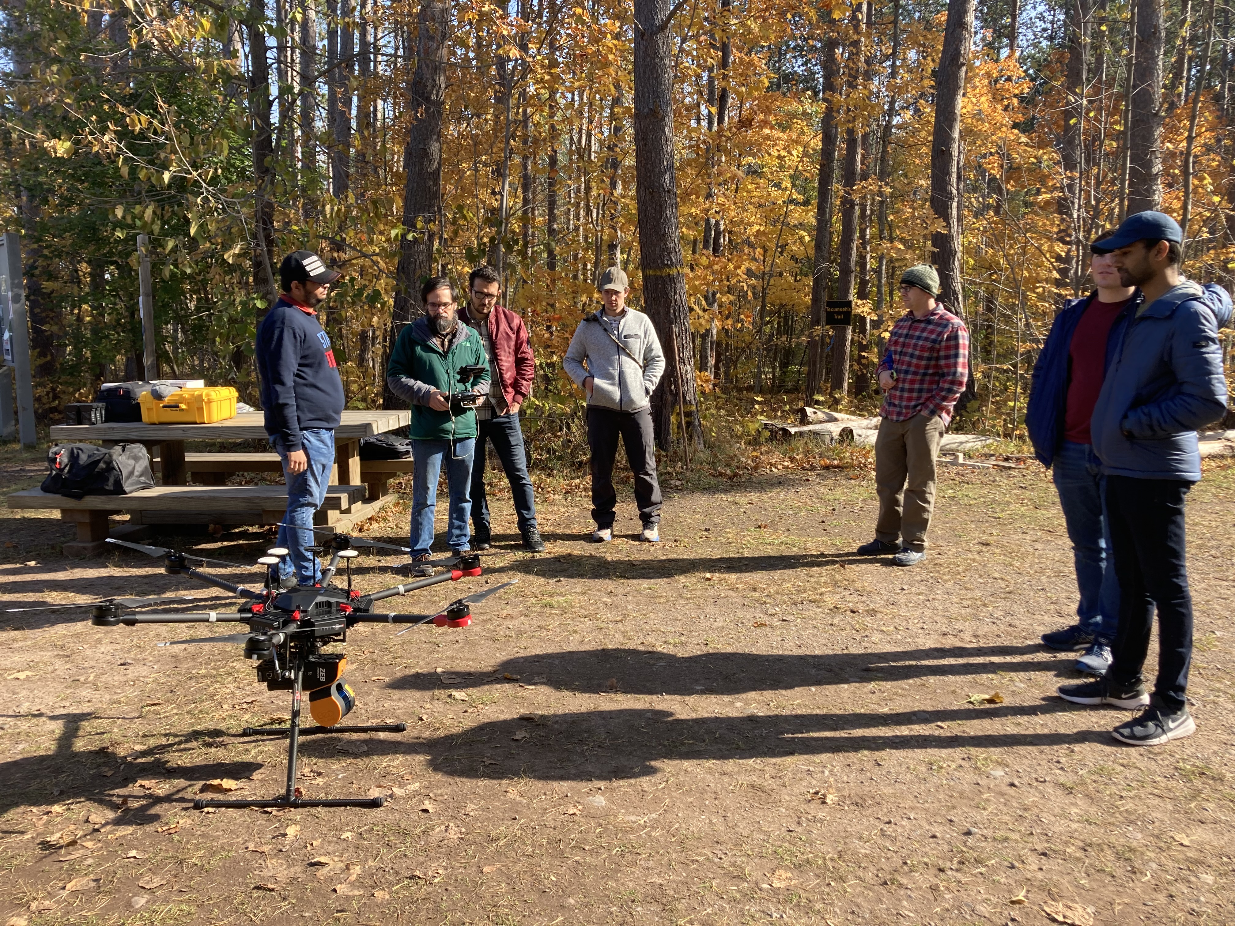
Phenotyping of individual trees in natural forest
- Utilize LiDAR data to precisely map the individual trees in natural forests.
- Employ LiDAR data for detailed analysis of morphological traits at the individual tree level, including measurements of height, stem form, diameter at breast height (DBH), and leaf characteristics such as leaf area index (LAI), leaf area density (LAD), color, distribution, and angle, along with canopy features like volume, coverage, structure, and phenological aspects (e.g., flowering periods, leaf coloration timing, leaf expansion, and leaf fall).
- Process optical remote sensing data to assess biochemical traits, including chlorophyll and lignin content, and water use efficiency at the individual tree level.
People

Tao Liu, PhD, Principal Investigator
I came to Michigan Tech in August 2020 after I finished two years’ postdoc training in Oak Ridge National Laboratory. Before that, I spent four years in University of Florida to pursue a PhD degree in Geomatics and MS degree in Statistics simultaneously after I obtained a MS degree in remote sensing area from SUNY ESF in 2014.
My research interest focuses on utilizing computing and remote sensing techniques to solve problems related to natural resource management, ecology, natural disaster mapping, vegetation property extraction, and urban remote sensing.
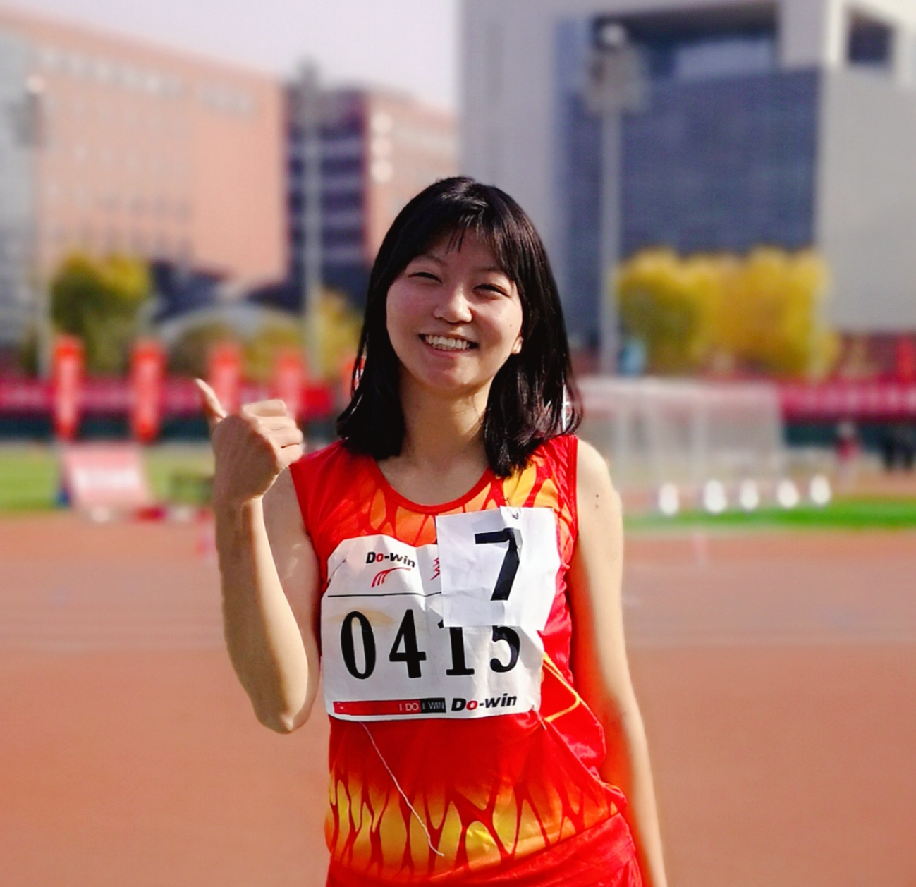
Judy Long, PhD Student
I am Judy Long from China. My research interests are forest mortality mapping and tree health prediction in the context of climate change based on remote sensing technology and deep learning models.

Stelle Barone, PhD Student
Upcoming in 2024 Fall
I am a first-generation college student and a third-generation American. This is the second degree I am pursuing through the CFRES at MTU. My research interests are ecologically focused remote sensing and data science projects. In the future, I want to apply research and teach machine learning skills to natural resource focused groups and individuals.
Sri Renganath Rengarajan, Master of Science
Research Assistant, Graudated in 2023 Fall
I originate from the southern region of India, with a keen academic focus on remote sensing, Lidar processing, and programming. Recently, I've developed a burgeoning interest in Deep Learning and am actively delving into its intricacies.

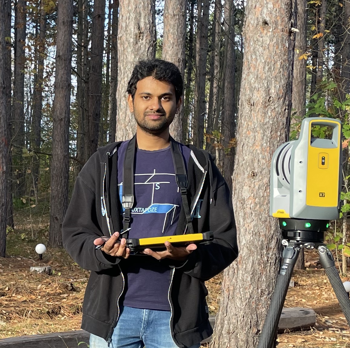
Ashish Mahaur, Master Student
I am from India where I graduated in Geology and it encouraged me to specialize in Remote Sensing and Geospatial Technologies. My research interests lie in applying Machine Learning and Deep Learning to the field of Remote Sensing applications.

Hongxiang Wang, PhD, Visiting Scholar
I came from China. My research primarily explores the dynamics of forest spatial structure and its correlation with forest functioning, such as productivity. Currently, I am engaged in collaborative research with Dr. Tao Liu as a visiting scholar. My interest lies in leveraging LIDAR techniques to accurately quantify forest canopy structure and investigate how inter-tree interactions impact the forest structure and growth, viewed from a 3D perspective of individual trees.
Teaching
In Michigan Technological University, I teach students to analize the remote sensing images with coding skills
FW5540/4540 Remote Sensing of Environment
In this course, students will learn the basic theory of remote sensing, where to find remote sensing data, how to download and analize remote sensing data using Google Earth Engine, and ArcGIS Pro
FW5560 Python programming for GIS
In this course, students will learn how to automate their workflow of GIS data processing with ArcPy and open source GIS\RS packages such as GDAL, Rasterio
Selected Publications
Liu, T., Yang, L. and Lunga, D., 2021. Change detection using deep learning approach with object-based image analysis. Remote Sensing of Environment, 256, p.112308
Liu, T. and Abd-Elrahman, A., 2018. Multi-view object-based classification of wetland land covers using unmanned aircraft system images. Remote Sensing of Environment, 216, pp.122-138.
Liu, T., Abd-Elrahman, A., Zare, A., Dewitt, B.A., Flory, L. and Smith, S.E., 2018. A fully learnable context-driven object-based model for mapping land cover using multi-view data from unmanned aircraft systems. Remote sensing of environment, 216, pp.328-344.

Liu, T. and Abd-Elrahman, A., 2018. Deep convolutional neural network training enrichment using multi-view object-based analysis of Unmanned Aerial systems imagery for wetlands classification. ISPRS Journal of Photogrammetry and Remote Sensing, 139, pp.154-170.
Liu, T., Im, J. and Quackenbush, L.J., 2015. A novel transferable individual tree crown delineation model based on Fishing Net Dragging and boundary classification. ISPRS journal of photogrammetry and remote sensing, 110, pp.34-47.
Liu, T., Abd-Elrahman, A., Morton, J. and Wilhelm, V.L., 2018. Comparing fully convolutional networks, random forest, support vector machine, and patch-based deep convolutional neural networks for object-based wetland mapping using images from small unmanned aircraft system. GIScience & remote sensing, 55(2), pp.243-264.
Liu, T., Abd-Elrahman, A., Dewitt, B., Smith, S., Morton, J. and Wilhelm, V.L., 2019. Evaluating the potential of multi-view data extraction from small Unmanned Aerial Systems (UASs) for object-based classification for Wetland land covers. GIScience & remote sensing, 56(1), pp.130-159.
Bhattarai, N. and Liu, T., 2019. LandMOD ET mapper: A new matlab-based graphical user interface (GUI) for automated implementation of SEBAL and METRIC models in thermal imagery. Environmental modelling & software, 118, pp.76-82.
Liu, T. &Abd-Elrahman, A., Multi-View, Deep Learning, and Contextual Analysis: Promising Approaches for sUAS Land Cover Classification, Chapter 7 in Sharma, J.B. (Ed.). (2019). Applications of Small Unmanned Aircraft Systems: Best Practices and Case Studies (1st ed.). CRC Press. https://doi.org/10.1201/9780429244117
Qin, R. and Liu, T., 2022. A review of landcover classification with very-high resolution remotely sensed optical images—Analysis unit, model scalability and transferability. Remote Sensing, 14(3), p.646.